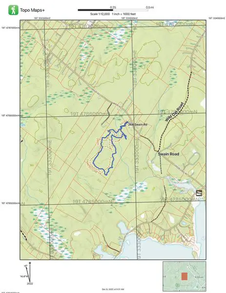
A map and a compass go together like a hand and a glove – they really complement each other. There are many types of maps available some being very basic sketches of a conservation area identifying trails, features, and rough boundaries. The gold standard, if you will, is the USGS Quadrangle Sheets which used to be very common to buy but I suppose you would have to order on line or get at a specialty store. I choose to print my own and in this case fro Topo Maps + Hunt. The hunt version is an annual subscription and includes lots from the municipal tax map system.
Maps are a scale representation of a location and are projecting a three dimensional reality onto a flat surface. When we are looking at a relatively small area such as these it is not much of a factor but you are also projection a round object onto a flat surface. Maps have many common elements which usually start in the margins. These are referred to as Marginal Elements and include the scale of the map, the north rotation, grid references, and naming information. The scale of a map is generally given in a relationship such as 1” = 2000’, a ratio such as 1:24,000, and a bar scale. The bar scale and relationship to a ruler allow you to measure distances. The ratio usually controls how much detail you can get on a map. For my hiking adventures I usuall go with a closer detail and print my maps at 1” = 1000’ or ratio of 1:12,000. The ratio is literally comparing the difference of the map to the ground: one inch equals 12,000 inches or one foot equals 1 2,000 feet.
The convention is for True North to be up on a USGS type map. Land Survey maps – you really have to watch them because we rotate data to fit on a sheet of paper. The outside margins of a map reflect this True North and are usually identified as a latitude and longitude. You will also note that there are grid squares shown on these maps and they reflect Grid North based on a local grid system called UTM. I’m just going to drop that there for now – it is a much larger topic for a later date. The is also usually a North Arrow in the margins and it will tell you the documented difference netween True North and Magnetic North at the time of the map printing. This is known as the declination and is known to change. (Ouch) In my area in New Hampshire it is 14.5 degrees to the west and we are supposedly in an area of little or no change.
The grid system on a map allows you to plot coordinates for communicating and land navigation. Using a quality compass, a protractor, and map you can plot very accurate azimuths for traveling over the terrain. For today we are going to stick to the four cardinal directions. North, South, East, and West. These will help us get out of trouble.
The middle of the map shows you details such as roads, rail roads, wetlands, buildings, and … trails. In my case approximate property boundaries. The Topo maps also show you contour lines which reflect elevations in that every point on that line is of the same elevation above sea-level. Think of layers in a cake and rings of frosting. (Now I’m hungry.)
After setting the declination on our compass, you orient the map compass by using the outside margins and literally rotate the map so the north arrows agree. More on that later.
On my first map you see that Swain Road goes from NW to SE. That is Northwest to Southeast. If I get disoriented in the Barrington Town Forest my escape azimuth would be Northeast or NE. From any point on that property if I traveled NE I will hit that road, my SUV, and be home before my bride calls the proper authorities.
Stay safe, go out there prepared.
Author: Ken Berry

Leave a Reply